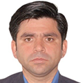
Dr. Muhammad Shafique is working as an Associate professor at the National Center of Excellence in Geology, University of Peshawar. He is also the Lab Director of the GIS and Space Applications in Geosciences (GSAG) laboratory established with the affiliation of the National Center of GIS and Space Applications (NCGSA). He holds an MSc and Ph.D. in GIS and Remote sensing for Geohazards assessment from the Faculty of Geoinformation and Earth Observation, University of Twente, The Netherlands. He has 20 years of experience in applications of GIS and remote sensing for geohazard hazard assessment, natural resources exploration, environmental studies, glaciers monitoring, and disaster risk assessment. His current research focus is on the multi-hazard risk assessment with a specific focus on landslides, debris flows, GLOF and earthquakes. He is also working on evaluating the impact of climate change on the changing natural of natural hazards and risks. He is leading the geospatial research group at his institute and is the principal investigator of many research projects from national and international donors. From his research, he has published more than 50 publications in reputed international journals and presented his research in dozens of conferences around the globe. He is a member of many committees at national and international level.